Page 55 of 104
Posted: Fri Nov 12, 2010 7:11 am
by Bear_130278
Posted: Thu Nov 18, 2010 11:02 pm
by Mel
Image Based Lighting using Spherical Harmonics. If irrlicht had loaders for images with HDR data, it would be perfect.

Posted: Thu Nov 18, 2010 11:25 pm
by Virion
nice!!
Posted: Fri Nov 19, 2010 1:00 am
by slavik262
Mel wrote:If irrlicht had loaders for images with HDR data, it would be perfect.
What image format has floating point light values?
Posted: Fri Nov 19, 2010 4:11 am
by Adler1337
@Mel Holy crap I think I just had an eyegasm!
Posted: Fri Nov 19, 2010 10:27 am
by Mel
Open EXR has supoprt for 16 bit and 32 bit precision floating point data images, among many others. It is an open format developed by Industrial Light & Magic.
http://www.openexr.com/
Posted: Sun Nov 21, 2010 10:45 pm
by Lonesome Ducky
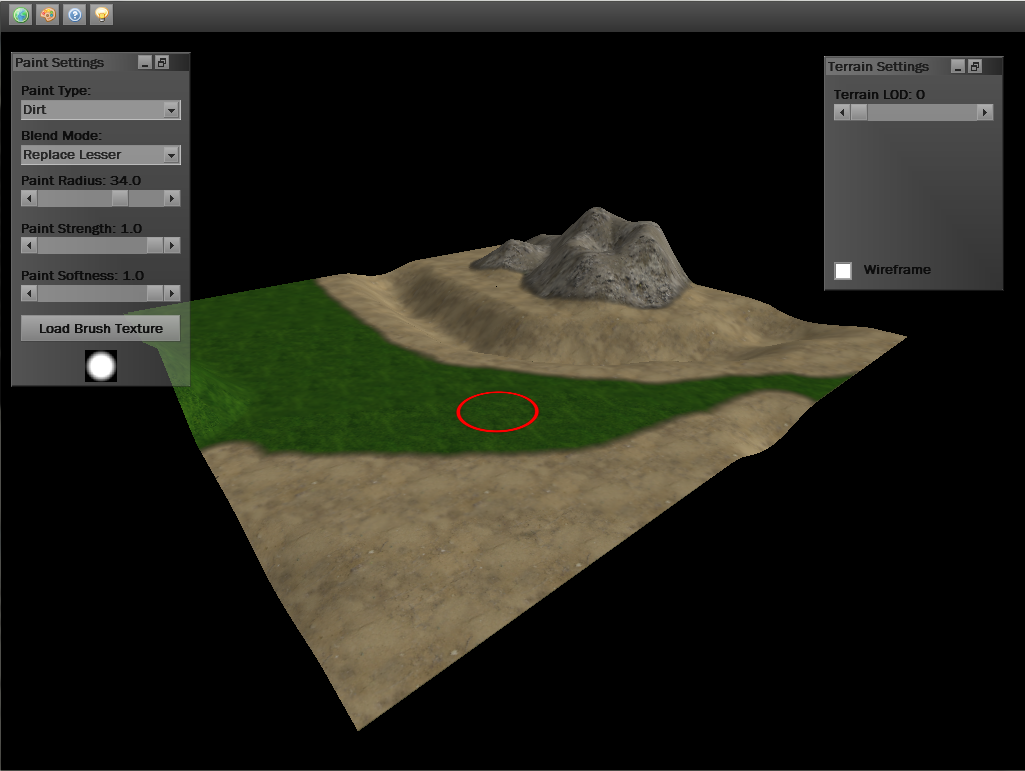
A terrain editor I'm working on for my current project.
Posted: Sun Nov 21, 2010 11:30 pm
by Virion
wow now that's something very interesting! good job Lonesome Ducky! are you using glsl?
Posted: Mon Nov 22, 2010 12:42 am
by 3DModelerMan
How did you get the heightmap info from the terrain scene node?
Posted: Mon Nov 22, 2010 1:47 am
by Lonesome Ducky
Virion wrote:wow now that's something very interesting! good job Lonesome Ducky! are you using glsl?
I'm actually using HLSL, I'm sure devsh would kill me if he were still here

3DModelerMan wrote:How did you get the heightmap info from the terrain scene node?
It's actually my own custom scene node, because it requires a lot more than I could get out of the regular one. But basically, I go through all the vertices to find the highest one. Then, I divide every other vertex by the highest point, and times by 255. That gives me the color for that place on the heightmap.
I made the tool myself because I need the terrain to tile with itself, and I didn't know of any tool that could do this. I plan on making the world wrap around itself, and I made it so this effects it like it's connected to itself on all 4 edges. Kinda weird to think about, but it's helped me alot
Posted: Mon Nov 22, 2010 2:00 am
by Virion
I'm actually using HLSL, I'm sure devsh would kill me if he were still here
he will try to convert you to his open source based, opengl powered religion
Posted: Mon Nov 22, 2010 6:05 am
by Insomniacp
I made a similar system without using shaders. I found a height map insufficient for my needs so I actually just saved each vertices height to a file and rounded the numbers to 2 digits. The file size was smaller and the height more accurate imo. I have the files on my computer but the include paths are formatted for windows.... if it compiles again on windows I will post a screen shot of it. Its features were blending the textures directly onto the texture of the map, this texture is then saved to a png (or maybe bmp...) file. It then saves the height of each vertex in a separate file along with other data like map position so it can load maps around it easily. When I loaded the maps I edited the vertex buffer directly to set the heights in a quick manner. I believe I threaded out the loading of the maps as well, not sure if I did it safely though at the time. I will post source code as well once it compiles again. It most likely was a botched attempt but its a good proof of concept. The textures need to be big enough to cover the whole map though I believe i set it up to automatically tile those that are not.
Found an image:
http://www.rofhonline.com/mapeditor.bmp
The black line is the edge of a map so you can see that if the texture is tileable then it will even tile across maps properly. The gui was also not as useful as it could be, no slide bars

If you are interested in source code send me a pm and I will send it to you now since I may not have time to compile the code this week.
Posted: Mon Nov 22, 2010 7:43 pm
by fmx
@Lonesome Ducky
Do you plan on releasing the Editor?
Even if it was closed source and only exported out a greyscale heightmap image, it would be really cool and much appreciated.
I use tileable terrains in a couple of my own projects, and trying to paint heightmaps which can tile on all sides is a PITA
@Mel
is that a decal effect or a texture map on the car?
you could implement HDR into standard RGBA images by using RGBE/loglan/etc, floating point formats aren't the only way of doing it
Posted: Mon Nov 22, 2010 10:07 pm
by Lonesome Ducky
I was actually thinking of releasing it and the source. It's quite far from finished though. I need to speed up the painting, allow light mapping, create perlin noise etc. I estimate that'll be in a useable stage in a few weeks or so. Just be aware that my code is pretty ugly
Thanks for the interest in it though guys, I'll be sure to post a project announcement when I feel it's ready to be used. Right now I'm struggling a TON with speed. A 100px radius texture brush brings the program to around 150fps on my computer. Not quite as fast as I want it

But I did a test with earth sculptor and it struggles to get 24fps with the same size brush.
Posted: Tue Nov 23, 2010 1:49 am
by Mel
@fmx: No, i edited the original texture a bit and added one of my pics Decals cold be too much to add for a shader, i mean, with the potential of shaders, just adding a picture over another is a waste of resources

.
With regard to the terrain editor: it looks pretty awesome! I wonder if it would be too hard to create a terrain which had one texture per vertex that blended with the neighboring vertices, and that the heights could still be edited as a single mesh.


